Some of my favorite tropical weather sites -
Stormcarib - a year round page of island weather reports from various Caribbean islands, as well as a pro met synopsis, connections to the National Weather Service, plus tons of weather information concerning the Caribbean. This is probably my favorite go to page.
Wunderground Tropical - a great page for visuals, models, NWS updates etc.
Suzanne from Finca del Seto - Suzanne will email you a daily weather update (plus some occasional neat bits she finds) if you email her at this address and ask to be added to her list. She also sells awesome coffee from the finca!
Storm 2K Talkin' Tropics - this is a forum style page, and sometimes you have to wade in a bit to get relevant information, but usually not. When the weather goes active, they have an active weather page that is full of good info supplied from professional meteorologists as well as some pretty bright amateurs.
NWS San Juan discussion page - daily (more if necessary) reports from the NWS for the local area (you can get these emailed daily, starting June 1 through November 30)

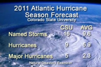
What's expected this year, storm wise? Check out the the long version of the above (see graphic) yearly predicted forecast here. Or here, for variety on a theme.
What you can do in pro-active preparations (and what you should do, the better prepared you are the better you can help yourself and your neighbors should the need arise) to be as best prepared as possible for a storm. It doesn't have to be a Hugo to leave us powerless and waterless.
 |
| Paths of hurricanes through our area over the years |
Also - it's mentioned below but - don't forget to add board games, cards, crayons & paper, books etc to your readiness kit. Fun is good and if the power goes out for a long stretch, fun is necessary!)
Water - at least 1 gallon daily per person for 3 to 7 days
— non-perishable packaged or canned food / juices
— foods for infants or the elderly
— snack foods
— non-electric can opener
— cooking tools / fuel
— paper plates / plastic utensils
— insurance, medical records, bank account numbers, Social Security card, etc.
— proper identification / immunization records / medications
— ample supply of food and water
— a carrier or cage
— muzzle and leash


Today's first report I got via email; usually much shorter, this lets you know how to subscribe and what is being offered.
TROPICAL WEATHER OUTLOOK
NWS NATIONAL HURRICANE CENTER MIAMI FL
200 AM EDT WED JUN 1 2011
FOR THE NORTH ATLANTIC...CARIBBEAN SEA AND THE GULF OF MEXICO...
A SMALL LOW PRESSURE SYSTEM LOCATED ABOUT 300 MILES EAST OF
CHARLESTON SOUTH CAROLINA IS PRODUCING A CONCENTRATED AREA OF
SHOWERS AND THUNDERSTORMS. ENVIRONMENTAL CONDITIONS ARE NOT
FAVORABLE FOR SIGNIFICANT DEVELOPMENT OF THIS SYSTEM BEFORE IT
REACHES LAND IN THE NEXT DAY OR SO. THERE IS A LOW CHANCE...10
PERCENT...OF THIS SYSTEM BECOMING A TROPICAL CYCLONE DURING THE
NEXT 48 HOURS AS IT MOVES WEST-SOUTHWESTWARD AT 15 TO 20 MPH. FOR
ADDITIONAL INFORMATION ON THIS SYSTEM...PLEASE SEE PRODUCTS FROM
YOUR LOCAL NATIONAL WEATHER SERVICE OFFICE.
ELSEWHERE...TROPICAL CYCLONE FORMATION IS NOT EXPECTED DURING THE
NEXT 48 HOURS.
TODAY MARKS THE FIRST DAY OF THE ATLANTIC HURRICANE SEASON...WHICH
WILL RUN UNTIL NOVEMBER 30. LONG-TERM AVERAGES FOR THE NUMBER OF
NAMED STORMS...HURRICANES...AND MAJOR HURRICANES ARE 11...6...AND
2...RESPECTIVELY.
THE LIST OF NAMES FOR 2011 IS AS FOLLOWS:
| Arlene | Bret | Cindy | Don | Emily | Franklin | Gert | Harvey | Irene | Jose | Katia | Lee | Maria | Nate | Ophelia | Philippe | Rina | Sean | Tammy | Vince | Whitney |
------------------------------
THIS PRODUCT...THE TROPICAL WEATHER OUTLOOK...BRIEFLY DESCRIBES
SIGNIFICANT AREAS OF DISTURBED WEATHER AND THEIR POTENTIAL FOR
TROPICAL CYCLONE FORMATION DURING THE NEXT 48 HOURS. THE ISSUANCE
TIMES OF THIS PRODUCT ARE 2 AM...8 AM...2 PM...AND 8 PM EDT.
AFTER THE CHANGE TO STANDARD TIME IN NOVEMBER...THE ISSUANCE TIMES
ARE 1 AM...7 AM...1 PM...AND 7 PM EST.
A SPECIAL TROPICAL WEATHER OUTLOOK WILL BE ISSUED TO PROVIDE UPDATES
...AS NECESSARY...IN BETWEEN THE REGULARLY SCHEDULED ISSUANCES OF
THE TROPICAL WEATHER OUTLOOK. SPECIAL TROPICAL WEATHER OUTLOOKS
WILL BE ISSUED UNDER THE SAME WMO AND AWIPS HEADERS AS THE REGULAR
TROPICAL WEATHER OUTLOOKS.
A STANDARD PACKAGE OF PRODUCTS...CONSISTING OF THE TROPICAL CYCLONE
PUBLIC ADVISORY...THE FORECAST/ADVISORY...THE CYCLONE DISCUSSION...
AND A WIND SPEED PROBABILITY PRODUCT...IS ISSUED EVERY SIX HOURS
FOR ALL ONGOING TROPICAL CYCLONES. IN ADDITION...A SPECIAL ADVISORY
PACKAGE MAY BE ISSUED AT ANY TIME TO ADVISE OF SIGNIFICANT
UNEXPECTED CHANGES OR TO MODIFY WATCHES OR WARNINGS.
THE TROPICAL CYCLONE UPDATE IS A BRIEF STATEMENT TO INFORM OF
SIGNIFICANT CHANGES IN A TROPICAL CYCLONE OR TO POST OR CANCEL
WATCHES OR WARNINGS. IT IS USED IN LIEU OF OR TO PRECEDE THE
ISSUANCE OF A SPECIAL ADVISORY PACKAGE. TROPICAL CYCLONE UPDATES
...WHICH CAN BE ISSUED AT ANY TIME...CAN BE FOUND UNDER WMO HEADER
WTNT61-65 KNHC...AND UNDER AWIPS HEADER MIATCUAT1-5.
ALL NATIONAL HURRICANE CENTER TEXT AND GRAPHICAL PRODUCTS ARE
AVAILABLE ON THE WEB AT WWW.HURRICANES.GOV. SIGN UP FOR PRODUCT
UPDATES BY EMAIL AT WWW.HURRICANES.GOV/SIGNUP.
CASE. YOU CAN ALSO INTERACT WITH US ON FACEBOOK AT
WWW.FACEBOOK.COM/US.NOAA.
$$
FORECASTER BRENNAN
~~~~~~~~~~~~~~~
Tomorrow I'll be back with the other side (or other or other side) of living in Paradox. In the meantime, have a weather instructive Wednesday. Do something to up your wisdom.
No comments:
Post a Comment